Monday, August 2, 2010

The Gulf Country

River bed between Georgetown and Croydon.

  
The Gilbert River, off peak.

The Little River, only a few kms past the Gilbert River


At Croydon, a rig pulled up for fuel which made every couple with a Toyota Landcruiser with a tinny tied on top momentarily regret they had not put more into their super.

Note the hydraulic lift to lower the boat to the lower deck level. But was he happy? Actually, he did look pretty pleased with himself. Ah well, he has at least 16 tyres to check and replace, I only have 2. But I doubt that point of distinction is causing him any loss of sleep.


I spotted a brolga in scrub beside a river bed. For some reason I did not expect this bird to be able to fly. If you knew that brolgas flew, I don’t care, and further you would not have had the wonderful surprise I had when this bird took to the air. We don’t get brolga in Thornbury, and they are not part of the Wurrundjeri dreaming.

It was like watching a prototype aircraft get airborne. Surrounded by scrub, it did a standing near vertical confined space takeoff with its long slender wings plying the air in slow motion, followed by a series of low speed turns around obstacles, while at the same time retracting its undercarriage in a somewhat disorganised manner. The takeoff was a thrill to watch. You see, ignorance can do that for you. Those burdened with the knowledge that brolga can fly would probably have just yawned.

Once above the scrub line, it went from near hover mode to forward flight and flew a few circles and gathered speed, and quickly assumed a most beautiful fully streamlined aerodynamic profile. From head to toe it was a gentle curve like the upper surface of an aerofoil in cross section. Its pencil-thin legs were now trailing motionless and tidily behind in its slipstream, and its head and neck were sliding effortlessly through the air. Its wings are large and obviously powerful. It accelerated with ease and set heading at low level and was quickly out of sight.


I have seen many brolga in the days since this first sighting.  They often fly in formation. They are mostly in groups on the ground. A feature of the species is that they can takeoff and disappear faster than a motorcyclist can stop, get his Nikon out and press the shutter. The above is not a good photo, but as brolga photos go it is better than photos of points from which brolga have very recently left.


The pelican has long been my favourite bird – the true master of low and slow precision  flight, yet they can also thermal effortlessly to miles above the surface of the earth and fly huge distances. But I have not seen a more beautiful bird than the brolga.


This is a swamp with water lilies just out of Normanton, which had all sorts of birdlife including large flocks of brolga, which all disappeared as I appeared.


Where the brolga were.


Accommodation in Normanton

The yellow addition to my luggage is a 12 litre bladder for extra fuel.


The heavily corrugated road between Normanton and Burketown was a good test for the new luggage setup. It passed with flying colours. The 12 litres will give me around an extra 200kms. The tank on the GS holds 20 litres, which is not enough in this part of the world. I also have an 8 litre version of the same thing. Together with the 12 litre bag that will let me double my fuel endurance.

My Kathmandu one man tent has a zip and fly system which is said to keep out bugs and other unwanted intruders. That feature will be well tested should I encounter any relative of this monster, which meets all my criteria for 'unwanted intruder' designation.
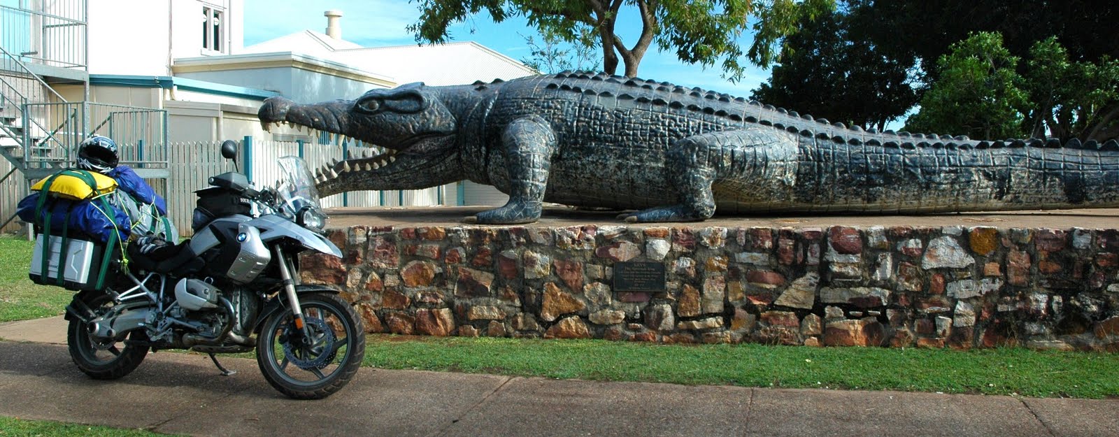

This is a replica, built to scale, of an estuarine crocodile caught just downstream from Normanton in the Normanton River in 1957. It was 8.63 metres long, and estimated to weigh around 2 tonnes. What does it eat? Anything it wants etc etc


I will certainly be zipping up the tent if camped near water. Actually, the advice everywhere is not to camp near water, and to camp a ‘safe distance’. But what is a ‘safe distance’? I am thinking at least two states might be adequate. You see, salties don’t play fair. At least the great white pointer understands the basic rule that if you make it to the shore, you win. They respect this rule. But salties don’t. If you are standing on the shore they will come and eat you. There are no rules with salt water crocodiles.


Asking for croc safety advice is unfortunately a cue for most people around here to try their hand at the comedy thing. One person told me that big crocs have a bad turning lock, and so if you run around in tight circles they will stay close, doing their wider circles around you, but won’t actually be able to eat you. You might have to do this for a couple of days and nights of course. Personally, I might just go for the straight line and a 100 metre PB.

Just look at this water for a moment.

Where the crocs are.


This is the water you can’t stand near. This is water with crocs in it. This is water near which you can get plucked from your enjoyable life and eaten. Unlike the above photo of where the brolga were, this is where the crocs are. I won’t go on, but I found it interesting.


Burke and Wills camp site number 119 of 1860/61. A recently published book about Burke and Wills called “The Dig Tree” by Sarah Murgatroyd will capture your interest. It was worth the diversion down a very rough track to stand in the harsh quietness of this lonely part of the Gulf Country and to contemplate what it must have been like to be there 150 years ago, in the plight in which Burke and Wills found themselves.

There were some epic feats of droving in the early years of white settlement in this country. In 1881 Bluey Buchanan left south east Queensland with 20,000 cattle and 70 men under his command. He took them across the state to the Daly River area. Apparently, like me, he spent the first few nights dropping in on old friends who had offered him a bed anytime. But the welcomes were luke warm at best, so they camped after that.


Typical river crossing between Normanton and Burketown.

I saw a caravan and 4WD on the side of the road, and pulled over as is the custom on these lonely roads to ensure they were OK. They were, and the cup of tea and biscuit they provided to me were most welcome.  Just as complete strangers feel at liberty to chat to each other in emergencies, so it is on these remote roads. The incipient emergency ambience of the place eludes none, except perhaps for the Doomadgee footy team who were heading home victorious from Normanton in their own version of the Dakar. It may very well be more comfortable on these roads in vehicles which only touch the road occasionally.


There was a lot of this between Normanton and Burketown.


I had a few ‘moments’ on the gravel on sections of corrugations from hell, and on deeper than usual gravel build-ups. I spent about one-third of my time on the dirt road between Normanton and Burketown standing on the footpegs, as a matter of necessity, not style. It truly is more comfortable, and there is no doubt the bike is more stable and controllable. It is surprisingly comfortable so long as your legs are not bent or not bent too much. I had both tyres at 30psi not 25psi today as a concession to the load I am carrying. I will try 25psi tomorrow.

Ants just love it out here.

Slavishly following GPS commands today would certainly have seen me carving my own dig tree by the end of the week. That pommy woman from Garmin had a lot of strange suggestions today. Frankly, I don’t think she’s ever been out here.


The map is the number one navigation aid.


The magnificent Albert River just south of Burketown

I am sure this fellow in Burketown is a consummate tradesman with pride in his work, and that she’ll be up and running by the end of the week. It’s just that I have never seen a scene like this in any garage in Victoria, or anywhere.


Not so shiny now.

Frank at the Burketown Information Centre was very knowledgeable about the roads in the Gulf Country and what he didn’t know, he found out by making phone calls.


Frank confirmed what others have been telling me, that the Calvert River is too high for the GS to cross on my originally planned route to Borroloola via Doomadgee. So I am heading south-west tomorrow morning to Lawn Hill National Park, via Gregory Downs. I will spend tomorrow night at Adels Grove. The best information available is that the roads will all be passable. They involve a few river crossings, but the river crossings quickly get shallow as you go further inland from the coast of the Gulf.

From Lawn Hill I will go south to the Barkly Highway just east of Camooweal, then to Barkly Homestead Roadhouse, then up the Tablelands Highway to Cape Crawford. There I will get further information about river heights, and decide whether I can go to Mataranka via Roper Bar (the more interesting route by far I am told), or will have to go west on the bitumen to Daly Waters on the Stuart Highway. I will need all my additional fuel capacity over the next few days for some long legs between fuel stops.


By the way, if you left click on any of the photos on this blog, you should get a bigger high resolution version of the picture.

(This was typed on Sunday, and posted on Monday)

Saturday, July 31, 2010

Heading West

I turned left today.  I have finished with north for the time being and I really will only be needing west for the next few weeks.

The mainland beaches of far north Queensland are very ordinary. Exhibit A:


Rex Lookout north of Cairns.
Hang-waiting is the same the world over.


Someone's day ended badly between Port Douglas and Mossman yesterday. Single vehicle accident, perfect weather, dry roads, light traffic.  Thought of you Griggsy when the helicopter landed in the middle of the highway to medevac the injured occupants.  You must have flown quite a few similar missions.  I find it heartening in Australian society the lengths we go to look after each other in emergency situations.  Three different emergency services were in attendance. Traffic was held up in both directions for over an hour, ending up stretching 3-4kms in both directions.  Occupants were out of their cars roaming around and chatting to total strangers as they do on such occasions. There was not a murmur of complaint. 


The Daintree is a big river, and deep within its adjacent rainforest a decent espresso can be found.


Road signs in the Daintree are unlike those found in our capital cities.


The first warns of the cassowary, which while not an apex predator, is apparently an apex nuisance with little road sense. As the sign shows, it is prone to standing on its own foot and cannot get out of the way. The second sign is more interesting, and I must confess I was unaware that if you keep one set of wheels on a concrete causeway in fast flowing water, the other half of the car will float. That is good to know.


When you get out west of the Great Dividing Range they try to scare you with pictures of cows eating cars. I didn’t buy it for a minute.


I mean, I saw something that looked like a cow only thinner, with no horns and its ears on upside down, yet it steadfastly refused to even sniff the GS.

A cow-like creature refusing to eat my motorbike as advertised,  having been given opportunity.

But back to the Daintree for a moment. They do tree canopies over roads very well there. Moisture is ever present in all its forms. The non-stop winter south easterly blows moist warm air onto the coast and mountains, creating huge banks of cloud which envelop the higher peaks and ridges. The humidity is very high, and there is slowly swirling mist in unexpected places in the forest and roads through it. Dampness pervades all. Despite a willing wind, complete cloud cover and drizzle, the temperature was steady around 28-29C.


At a look out which presents panoramic views of the southern coast and hinterland of the Daintree, is a sign.


I think I had a bit of a feel for the language, and certainly for the people, and I took the sign as a command. So I had a bit of a wahluoogideegah myself. It felt good. Coming from Melbourne I am of course much more familiar with the Wurrundjeri tongue, which I often dream in.


Tropical rainforest doesn’t follow any of the rules for plants. For example the old rule of one plant one stem/trunk is out the window. All manner of unholy liaisons must go on under cover of the mists deep in the jungle, probably at night, producing plants with features of many species but somehow all living off the one stem or trunk. Someone should sort this out.


There is a section of 20kms or so of curves which climbs up between Mossman and Mount Molloy to the Atherton Tableland. This stretch should be in the top 10 rides in Australia. It was unexpected, uncrowded and exhilarating.
 
Once on the Atherton Tableland the road continues to climb to over 3,000 feet above sea level. This is magnificent country. The coastal hills and mountains dry out the moist air from the sea, and all that remains of it are huge banks of cumulus now to the east like a fat doona over the mountain tops. The tableland has rich red soil, pasture which attracts fat shiny cattle from all over and cool air. It got down to 20C as I rode through the undulating curves on virtually uninhabited roads. The cattle are all blue ribbon specimens, the towns look prosperous, the farm houses do not bespeak struggling, and it’s enough to make you want to be a farmer.
 

But continuing west of the Great Dividing Range, and it is quite a different story. Even the gum trees bespeak struggling. The moisture-laden winds which are so generous to the coast and extended hinterland, have nothing left past a certain point inland. It shows. There were no clouds, there was no visible moisture anywhere, the temperature climbed to 32C, the wind died, the roads were long and straight. Once again, I was in a different place.


There is a species of ant which lives in large colonies, and constructs amazing anthills in which they reside. Because of the need for warmth early and late in the day, and the need to avoid the midday heat, these ants construct their huge dwellings on a long and narrow floor plan, cunningly oriented north/south so that it presents its smallest aspect to the cruel midday sun.

These ants should come and conduct a few workshops between Mount Garnet and Georgetown. The ant attitude here seems to be north shmorth, let’s just slap her together and move in - the bigger the better. There is no pride in workmanship here.


They should not be proud of this blob, maximising as it does heat retention from the sun at noon.

Of course ants vary in motivation and needs just as we do. I did spot this modest adobe abode away from all the others.  These ants are probably a bit alternative, a bit arty, and have a relation who is an architect. But alas, they also appear cavalier as to the location of north, magnetic or true.


An hour from sunset I refuelled in Mount Surprise. The main surprise was that there was no mountain. It was flat as something really flat (simile fatigue - I'm sure it will pass).


As I rode west totally blinded by the setting sun, using only the GPS to stay on the road, there was a short straight which went north and allowed me for a moment to look to my left and savour the splendour of the late afternoon sun west of the Great Divide. These were the colours.


Mossman to the Daintree, a wet world of mists and wildly imaginative vegetation. Cape Tribulation to the cool richness of the Atherton Tableland. All capped off with the relentlessly sun-punished beauty of the landscape west of the Great Divide.


It was a good day.

(This was written yesterday and posted today, Saturday).


Thursday, July 29, 2010

The Bruce Highway Finally Delivers

Today I rode from 10am to Townsville.

I woke in Proserpine to steady rain and high humidity which the locals assured me was unseasonal.  Nothing rustles in this humid environment.

50kms north of Townsville, the rain stopped, the sky turned blue and the temperature leapt from 22 degrees to 30 degrees C where it stayed for the rest of the day.

I rode into Bowen for breakfast at the Horseshoe Bay Cafe, and was greeted with scenes like this:


I did have my fruit Liz, in the form of sliced strawberries on thick white French Toast with health syrup.

Riding around Bowen with my summer gloves on, jacket undone, visor up, all liners removed and thermals packed away, the mighty GS purring quietly (due to BMW engineering and my efficient earplugs), Raybans doing their job, warm air flowing therapeutically over me, it occurred to me that to describe this would take a really long sentence. Seems I was right.

I have finally left the gravitational pull of Victoria. I am in a different place.

But believe it or not, that miserable Bruce Highway, notwithstanding its close proximity to coast like this to inspire it could only manage dust, brown grass, occasional uninteresting trees and pretty ordinary hills. This highway just doesn’t try.


However the girls at the Gumlu Fruit and Vege Chev try and succeed, and provided a bargain priced banana and a chat.


This was in contrast to a morning tea I had in a very small town south of Rockhampton the other day. Having established that a bus load of tourists had bought all the fresh apple pies (I wasn’t going to eat one Liz, I was going to bring it home for you), I ordered a black tea and a banana. “That’ll be a dollar and five cents,” I was told, in a tone which dissuaded me from entering negotiations with a view to rounding down to the nearest dollar. An excellent banana was produced after payment, together with a mug of black tea. After refusing sugar, and clarifying that the sort of black tea I wanted was without milk, I was asked if it was strong enough. I nodded affirmatively, and the server picked up the tea bag, strained it between forefinger and thumb into my cup, and took it out the back. I don’t know whether they peg them out to dry or have them dry cleaned for re-use or what, but $1.05 buys only a banana and the use of the tea bag at that establishment. It seemed that property in the tea bag did not pass to me upon payment as I had supposed it might. Tea bag hire I suppose you could call it. I must look into this.

As I approached Townsville, the mountains to the west suddenly became spectacular, and the sights more interesting. A steady 15-20 knot sou-easterly blows in from the sea for most of winter from what I can gather, and when that moisture hits the mountains it creates mist, low stratus and rain which affects the aesthetics and vegetation in the immediate area, in a good way.


Then north to more blue skies, which can make even the old Bruce Highway look tolerable.


I decided to stop and have a closer look at one of the roadside memorials to traffic accident victims. The white posts outnumber them up here, but not by a lot.


His name was Nick, and this is how some of those close to him chose to honour his memory.


It was a sad site, in many ways.


On to Townsville and a cabin looking over the sea to Magnetic Island.

The GS parked outside the reception office of the caravan park where I stayed in Townsville
Caught up with John and Heather (tanned nomads) who decided Townsville was preferable to Geelong for the winter.  Who could argue with that?


Thanks for lunch, breakfast and good company.

Now this is what I call a swimming pool. Northcote heated outdoor pool, even with its ducks, suddenly appears, well, less.


Solar heated seawater pool


Castle Hill is in the middle of Townsville. Views of and from respectively.


North today to Cairns and possibly beyond.
 
(This was written yesterday, and posted today)

Wednesday, July 28, 2010

The Bruce Highway.

The Bruce Highway and the landscape through which it passes are not things of beauty. There is a lot of this:


I rode 720 kms today (this post written Tuesday and sent Wednesday).  Grey overcast skies, rain and a solid sou' easterly wind were the order of the day.  The Bruce Highway is the last resting place for a lot of roos.  I rode on in hope that today would be a quiet day on that front, which it was.  I did see a couple of  young roos on a park in the middle of Agnes Water, but they were clearly town residents and don't count.

At a roadside rest area 130kms or so south of Mackay, I met Greg, sheltering from the rain and pondering where to camp for the night.  I rode a further 250kms for the day from the rest area, and Greg decided against pedalling on to St Lawrence due to considerations of daylight and a dirt road. St Lawrence was 14kms away. 


Greg left Perth 9 months ago on a pushbike odyssey.  He has a further 8 months or so on the road.  Apart from ticking off the compass extremities of the country (the easternmost point at Byron Bay, the most southerly point in Tasmania, the tip of Cape York and some point around Shark Bay in WA), Greg has wandered down every side road which has taken his fancy, and even a few which have not.  He has not shied away from dirt roads, alpine hill climbs or remote areas.

He carries all the gear he needs to camp every night.


 He made a casing to completely enclose his chain, sprockets and derailleur, to keep the dust out.  Excellent idea.  I hope you are taking notes Alan H.


And the final touch is a nose cone on the whole rig which Greg has found to produce less wind resistance than the plastic water bottle which it replaced. Everything I know about aerodynamics says he has to be right.  But unlike those very expensive  single purpose nosecones on propeller hubs on light aircraft, you can wash your face and do your dishes in the blue model.


Greg has done some other long bike rides - I think this is his fourth.  But I gather none quite as long as this.  I don't know what his mission is, or even if he has one.  But I sensed he was very contented on the road he has chosen to travel.

My ride is the antithesis of Greg's ride in just about every way.  Yet there was also some common ground. 

My plan for the day had been to ride from 1770 to Mackay (I know, this time/space thing is messing with my head too).  There are joys in not planning ahead when on the road, but finding out that there is a mining expo in Mackay and that every bed, cabin and camp site for miles around is booked out, is not one of them. 

I did take the time to photograph the Hotel Whitsunday in Mackay, which is a place of some pleasant memories for me.  Sadly, age has not treated it well.  I didn't linger.  Revisiting towns in which you once lived, after some decades, is like seeing an old friend who refuses to recognise you.  Good places are worth revisiting.  Good times don't have geographical coordinates. 

There being no room at the inn, and a marked absence of guiding stars, I made the decision as dusk fell to ride another 120kms to Proserpine, where courtesy of a Google search on the iPhone, I had a bed booked for the night. Having ridden 600kms already, this was not plan A.  Riding a motorbike at night is not fun and should be avoided.  The world narrows to the road ahead.  Left and right of the highway was reduced to the occasional sniff of sugar cane and roadkill.  It rained for most of this ride. Oncoming road trains were flanked by a bow wave of water and road grime, which was a bit like flying through a cloud at night, but with white posts to your left and traffic on a reciprocal heading 2 metres to the right. 

Pleasure in a meal is at least in part a function of how hungry you are and how well earned it was.  The fresh red emperor and excellent salad which I managed to procure just before the kitchen closed in Proserpine was a significant pleasure on both counts.